
Everique
Everique is a continent in the northern temperate zone of Corthis. It is separated from Japethe by the Levian Ocean on the east and bordered on the west by the Iyonic Ocean. Two mountain ranges stretch from north to south, dividing the continent into thirds. The mountains are high and imposing in the north before dwindling as they march to the south, where they become little more than rugged hills when they reach the southern coast. The western coast of Everique is said to be miles of dense temperate rain forest. Enormous lakes that could be considered small seas dominate the heartland of the continent. The eastern coast of the continent is heavily forested in the north with extensive marshes in the south.
Stephan Walsch crossed the Levian Ocean and landed on southwestern Everique (or Everlund in the Kennard tongue) in 1416. His voyage triggered the Age of Discovery when countless expeditions left Japethe to explore and colonize the new land. For nearly two hundred years, Japethan explorers sailed the coasts of the continent and used its many rivers to delve into the interior. Guiern, Saronne, Morante, Kleef, and the Freeports of the Kennard Reach all established colonies. Many of the colonies failed, but the waves of colonization continue to the present day and settlements now dot the eastern coastline. The largest of the colonies is Aradie, founded by Saronne, but the Kleefish colony of Meerpelt is growing quickly.
Everique was not uninhabited when Walsch made his voyage. Countless native tribes call the continent home. Most of the tribes on the eastern coast live as hunters and gatherers and do not have the technology to support large populations. These tribes are small and disorganized, and their interactions with the settlers vary greatly. The tribes that live near the lakes and along the rivers of the heartland are much more advanced. They have cities, and their numbers discourage Japethan settlement in the interior. There are tales of an empire that stretches along the west coast of Everique, but explorers to that land come back empty-handed or they don't come back at all.
Candelle Hills
The Candelle Hills are a group of tall hills to the south of the Grande Vire River. Unlike other hill formations, the Candelle hills do not form a chain. Rather, they seem to be remnants of a great dome of rock that later collapsed, leaving hundreds of steep hills. These hills would be high enough to be considered mountains but for the far taller and more imposing Ollegowi range to the south.
The Candelle Hills form the southern border of the colony of Aradie, which borders on the lands of the Liranequois Nation. The Liranequois claim the hills as their hunting grounds, though they have no settlements in the hills. During the Pelt Wars, the hills were the setting of many skirmishes between the colonists of Aradie and the Liranequois. Hostilities were resolved by the Grande Entente of 1669, but the Liranequois still fiercely defend their territory, removing any Japethan settlers by force if necessary.
Cape Adamant
Perhaps the greatest natural fortress on the eastern coastline of Everique, Cape Adamant is an impressive stone promontory that towers above the point where the Grande Vire River narrows. Toward the river, Cape Adamant presents a bold and imposing front with a sheer cliff that rises to a height of more than 100 meters. On the landward side, the decline is far more gradual, allowing easy ascent. Rockfalls tumble down the cliff face of the cape from time to time, endangering buildings and persons at the base. A number of caves worm their way into the towering rock formation. Most do not extend very deep and provide excellent hiding places for smugglers and other scallywags. However a few are thought to burrow far into the cape but are not large enough for a human to use. Explorers claim they sometimes hear anguished wailing coming from cracks in the deepest caves, but such tales are dismissed as tricks of the wind.
Nicolas Brunet discovered Cape Adamant in his explorations of the lands of Aradie in 1454. He found what appeared to be diamonds embedded into the stone, which give the cape its name. When Brunet's diamonds were revealed to be worthless quartz crystals, Saronne lost interest in the the area until Jaquet d'Artais founded a colony to establish trade relations with the natives for furs. Sherbourg, the capital of the colony, has grown significantly, with the Upper Town perched on top of the cape while the lower town grew along the harbor beneath the towering cliff face.
Grande Vire River
The Grande Vire River is a tremendously important waterway that runs northwest from Lake Chambenac to the Gulf of the Grande Vire. The river stretches approximately 750 miles and has numerous tributaries feeding it from the Trablais Mountains and the Candelle Hills. At its mouth, the Grande Vire is nearly five miles wide, but it narrows significantly at the city of Sherbourg. The river flows over a series of rapids downstream of Lake Chambenac, preventing river traffic from reaching the lake.
This wide river allows substantial access to northeastern Everique. The colony of Aradie is based entirely around the Grande Vire and its tributaries, and hundreds of fur trappers use the river as a highway to reach the interior where beavers are still plentiful. The native tribes that live alongside the river, such as the Elakanois, believe that a powerful spirit (called a manitou in their tongue) lives in its depths. They offer gifts and tribute to the river spirit in return for bountiful fishing.

The Great Grass Sea
Located to the west of the Sweet Seas, the Great Grass Sea is a vast expanse of treeless grassland that stretches for hundreds of leagues from the Lakelands to the Wall of the West. It is sometimes called the Prairie, deriving from the word for meadow. The first explorers from Japethe probably used that term because the Prairie was a break from the thick forests of eastern Everique. But meadow does not convey the enormity of the Great Grass Sea, which stretches to a distant horizon with softly rolling hills and tall grasses that wave in undulating patterns before the wind.
The soil of the Great Grass Sea is very thick, and the grass has roots that reach deep into the soil, allowing it to survive the frequent fires that sweep the Prairie. The land gets progressively higher and drier as you venture west, and as the soil gets drier, the grass gets shorter. In the east, the grass can be as high as your waist. At the foothills of the Wall of the West, the grass barely reaches the top of your shoes.
The Great Grass Sea is known for its raging wildfires and the savage winds that sweep across it. These fires burn away any trees that attempt to grow on the Prairie. Without trees, the wind can blow uninterrupted from the mountains in the west to the forests of the Lakelands. Sometimes the wind forms cyclones that are as spectacular as they are dangerous.
The Great Grass Sea is the home of many creatures unknown in Japethe. Vast herds of bison roam the Prairie in numbers beyond counting. Burrowing under the grass are the Dogmouse, a type of rodent that communicates by barking warnings to each other. Overhead, the western Thunderbird flies over the the Prairie from its nest in the Wall of the West. It cannot be seen as it covers itself in roiling thunderheads, but the beating of its wings resounds with thunder over the plains.
Gulf of the Grande Vire
Downstream of Sherbourg, the Grande Vire River gradually widens into an enormous gulf. This gulf acts as the estuary for all the Sweet Seas of the Lakelands that drain through the Grande Vire. The gulf is semi-enclosed, but three straits allow access to the gulf from the Levian Ocean. The gulf is a rich fishing ground which attracted fishermen from Japethe decades before Aradie was founded as a colony. These fishermen met the natives of the Odaneois tribe who fished these waters for centuries. The meeting was surprisingly peaceful and soon the two groups were trading goods.
The estuary where the Grande Vire River flows into the gulf is notoriously difficult to navigate. The swirling mixture of the freshwater current of the river and the incoming saltwater of the gulf makes the currents unpredictable and often dangerous for shipping. Additionally, the estuary is notorious for contrary winds blowing away from Everique. Ships can be stalled for days and sometimes weeks at the mouth of the river and within sight of land, which the sailors call "Cape Torment." The winds and currents have been growing worse in recent years -- almost as if the river is fighting the constant incursions by Japethan ships.
L’Heureux Falls
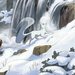
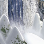
L’Heureux Falls is a waterfall some 83 meters (272 ft.) high. The falls are at the mouth of the L’Heureux River, where it drops over a cliff and plummets into a basin that feeds into the Grande Vire River 12 kilometers northeast and downstream from Sherbourg. In the winter, the icy spray from the falls forms a “sugarloaf” (so named because it resembles the form that refined sugar takes during processing). The sugarloaf is a large mound of ice and snow that accumulates on the frozen surface of the basin and can grow as high as 30 meters (98 ft.) and attracts ice climbers.
The famed explorer Jaquet d’Artais named the falls in honor of his patron Henri, duc d'Aunis who had the nickname “L’Heureux” at court for his jovial nature and his boisterous laugh. Jaquet’s patron was pleased with the homage and funded several more voyages to Everique.
Lakelands
The Lakelands is the region surrounding the five great Sweet Seas of northern Everique. The lakes are all interconnected via straits and rives to create a single network of waterways that stretches for hundreds of leagues. The banks of the lakes are heavily forested and often rocky, making the rivers and lakes the only easy means of travel through the Lakelands. The Sweet Seas are dotted with thousands of islands, some so large that they contain lakes of their own.
The land surrounding the Sweet Seas is fertile and the woodlands are well stocked with game. The presence of the large bodies of water warms the surrounding lands and lessens the impact of winter, allowing farming of maize, the all-important native grain, much further north than normally would be possible. Because of this bounty, the Lakelands is the home to many powerful native nations, including the Liranequois, the Elakanois, the Saultecois, the Cheveux Relevés, and the Alinouek.
Onyara Falls
The Onyara Falls is a set of three falls on the Onyara River that joins Lake Chambenac with Lake Lirane. The Crescent Falls is the largest of the three, while the two smaller falls, in order of size, are called Whitebeard and Little Sister. All three of the falls are more than 50 meters (165 ft.) high. The Crescent Falls is the most spectacular, stretching some 800 meters (1/2 mile) across. Together, the Onyara Falls drains the entirety of the Sweet Seas and an astounding amount of water tumbles over the edge in a breathtaking display of power.
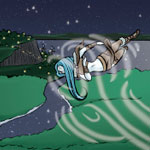
The Liranequois live to the south of the falls, while the Elakanois live to the north. Both tribes consider the falls a place of great power. Their legends hold that the falls is the home of three sibling manitou -- one for each of the falls. The oldest brother, called Water-like-Thunder, inhabits the Crescent Falls, which is the site of his greatest victory. A titanic water serpent was poisoning the Onyara River. Water-like-Thunder called down lightning to strike the monster, and the death throes of the serpent carved out the Crescent Falls. While its poison is no longer lethal, the venom still tints the waters of the Onyara a brilliant green. Behind Little Sister is a network of caves where the tribes leave offerings for the manitou of the falls in gratitude.
The Crescent Falls was first seen by a Japethan in 1519 when Jaquet d'Artais explored Lake Chambenac. He was overwhelmed by the beauty and power of the falls and named it the Crescent Falls in honor of Giavere. Since then, the majestic falls has become a holy site and a place of pilgrimage for the people of Aradie. Several attempts have been made to build a shrine to the Unicorn Maiden, but so far any structure dedicated to Giavere has met with misfortune, ranging from rockslides, to lightning strikes, to flooding.
The Sweet Seas
The Sweet Seas are a series of five freshwater lakes that dominate the landscape of north central Everique. These lakes are so enormous that Jacquet d'Artais thought that he found a way through Everique to the western ocean beyond. Many of the rivers of northern Everique empty into the Sweet Seas, which are in turn emptied by the Grande Vire into the Levian ocean.
The lakes act to moderate the temperatures of northern Everique, creating a basin of warm air, and allowing human habitation and cultivation of certain crops further north than is normally possible. The lakes are flush with aquatic life and provide a rich bounty of fish and mussels.
The Sweet Seas are prone to terrible storms that can blow up out of nowhere. Because the lakes are relatively shallow, winds can whip the lakes into frothing chaos. These winds are common in the late autumn. Navigation on any of the upper lakes is especially dangerous in the month of Barebranch when the winds howl down from the far north.
The natives of the northeastern woodlands hold the Sweet Seas in high regard as it is central to their sustenance and existence. In their myths, the Sweet Seas are the last remainder of a great ocean that once covered all the land. They believe that the deepest parts of the lakes connect to the underworld and it is the thrashings of the great spirits that live there that cause the sudden storms.
Lake Chambenac is the lowest of the Sweet Seas, and the great Onyara Falls separates the lake from the the other four. Because of its size and depth, Lake Chambenac never quite freezes over. The warm waters flowing into it from the Sweet Seas mix with the winds from northern Everique to create massive snowfalls on the eastern and southern shores of the lake during the winter.
Lake Lirane is the shallowest and smallest of the Sweet Seas. It is named for the Liranequois who dwell on its southern shore. Because of its shallow depth, this lake is the roughest. The lake is very temperate compared to the others with warm winds blowing up from the south.
Lake Elakais is the second largest of the Sweet Seas. It is named for the Elakenois who live on its northern and eastern shores. Lake Elakais is the most settled of all the lakes, boasting several large towns on its shores populated by the local native tribes. The lake has many great islands which are inhabited by the Elakenois for access to the excellent fishing ground and defense from the Liranequois to the south.
Lake Alinouez dips to the south, away from the other Sweet Seas. It is named after the Alinouek tribe who live along its western shore. Lake Alinouez is the deepest of all the lakes, and its shoreline is known for its sandy beaches. The soft, off-white sand is known by the natives as Singing Sand because it makes a high-pitched squeaking sound when walked upon.
The largest and most northerly of the Sweet Seas is Gitchigami (meaning Great Sea in the tongue of the Saultecois who dwell on its shores), also known as the Upper Sea. Gitchigami is icy cold year round. It is fed by more than 200 rivers, most of which originate from the runoffs of the glaciers to the north. Its shores are rocky and often rise in cliffs that tower over the water, making good harbors few and far between.
Trablais Mountains
The Trablais is a mountain range to the north of the Grande Vire River. These are old, weathered mountains composed of gneiss and slate. At nearly 4,000 feet above sea level, Mount d'Artais (called Cloudhat by the native tribes) is the highest point of the range, but the most famous peak is the Sleeping Giant, which bares an uncanny resemblance to its namesake.
The Trablais are covered in birch, beech, and maple, and are renowned for the brilliance of their fall foliage. Numerous lakes and streams create a writhing network of waterways through the mountain range, providing ample homes for the beavers that live here in countless numbers. The native tribes believe that the mountains act as the first barrier to Old Man Winter, who lives beyond the North Wind, and the mountains slow down his coming to the fertile lands to the south. Regardless of the truth of this tale, the Trablais do protect the river valley from the worst of the arctic winds that rage across the wastes of the far north.
Wall of the West
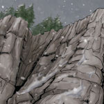
Far to the west of the Lakelands is the legendary Wall of the West. The mountain range runs nearly the length of the continent in a roughly north-by-northwest to south-by-southeast course. Not only is this the tallest range in Everique, but the mountains rise sharply from the Great Grass Sea with hardly any foothills to shield their impressive height. The Wall is particularly rugged with soaring cliffs and sheer faces of exposed stone. In places, enormous rock formations rise from the ground in sheets.
The Wall of the West boasts a wide variety of wildlife, much of which is dangerous. In addition to the elk, moose, and bighorn rams, the mountains are the home of a particularly large and fearsome bear. These great beasts guard their mountain homes from all comers, especially humans.
To date, the Wall of the West has barred the way to all Japethan exploration. Passes are few through the Wall of the West, and beyond the front range are even more mountains that are even higher and more jagged, wherein nests the western Thunderbird. The natives of the Great Grass Sea say that nothing lies beyond the Wall of the West, just a desolation composed of the sand, salt, and stone. But the great western ocean that separates Everique from Catai must lie somewhere beyond the mountains.
« Return to the Almanac Index